The Lauterbrunnen valley floor walk: Lauterbrunnen to Stechelberg
How long is the walk from Lauterbrunnen to Stechelberg?
It is 3.2km one way along the flat valley floor, roughly 45 to 60 minutes at an easy pace with no real elevation gain. Most people spend an extra hour at the Trümmelbach falls partway along, then catch the PostBus back from Stechelberg rather than walking both directions.
Why walk the valley floor instead of just visiting Trümmelbach
Most day-trippers arrive in Lauterbrunnen by train, walk the few hundred metres to photograph the Staubbachfall dropping past the church, then take a taxi or the PostBus straight to the Trümmelbach falls and back. That skips the part of the valley that makes Lauterbrunnen worth the detour in the first place: a flat, glacier-carved trench with sheer limestone walls on both sides, cascades falling from hanging valleys you can’t see the top of, and the Mürren and Wengen cliffs rising directly overhead. Walking it, rather than driving through it, is the only way to actually register the scale.
The route described here runs from Lauterbrunnen village to Stechelberg, 3.2km along the valley floor, entirely flat, following the road and the parallel path beside the Weisse Lütschine river. It passes the Staubbachfall near the start, several unnamed cascades along the cliffs, and the Trümmelbach falls roughly at the midpoint, before finishing at Stechelberg, the base station for the Schilthornbahn cable car up to Mürren and the Schilthorn. Most people walk down and take the bus back, which is what this guide assumes.
The route at a glance
| Detail | |
|---|---|
| Distance | 3.2km one way, Lauterbrunnen to Stechelberg |
| Walking time | 45–60 minutes at an easy pace, one way |
| Elevation gain | Negligible — the valley floor is essentially flat |
| Surface | Paved road with a pedestrian verge, gravel path in sections |
| Difficulty | Easy; suitable for pushchairs and most fitness levels |
| Return | PostBus, Stechelberg to Lauterbrunnen, roughly every 20–30 minutes |
| Main paid stop | Trümmelbach falls, around CHF 14 adults / CHF 6 children |
Getting to the start
Lauterbrunnen station sits on the line from Interlaken Ost, about 20 minutes by train, with departures roughly twice an hour. From the station it’s a two-minute walk down the main street to the village centre, where the Staubbachfall is already visible above the rooftops. There’s no need to arrive early for this particular walk — unlike the mountain railways, nothing here closes for wind or requires a timed ticket — but starting before mid-morning avoids the worst of the coach traffic through the village itself.
If you’re driving, park in Lauterbrunnen rather than trying to find space at Stechelberg, since the Stechelberg car park is small and fills early in summer, and you’d have to backtrack for the car anyway after walking one-way.
Lauterbrunnen to the Trümmelbach turn-off
Leave the village heading south, keeping the Weisse Lütschine river on your right. The road (and the footpath running alongside it, separated from traffic for most of the distance) hugs the base of the western cliff face — the same wall that Mürren and Gimmelwald sit on top of, invisible from here because they’re set back from the rim.
Within the first ten minutes you’ll have passed directly beneath the Staubbachfall, which at 297m is one of the highest waterfalls in Switzerland and looks genuinely impressive from below on a day with decent flow, though by late summer it can thin to little more than mist drifting off the cliff — snowmelt and recent rain do more for it than season alone. A few hundred metres further, the valley opens slightly and you get the first clear look down the full length of the trench toward the peaks at its head.
The path continues past a scatter of farms and campsites — this stretch of valley floor has several campgrounds taking advantage of the flat ground and the view, which is as good a reason as any to notice this is a working agricultural valley, not a theme park, even with the tour buses. Around the 2km mark, a signposted side path leads to the Trümmelbach falls entrance, set against the cliff on the right.
Reading the valley as you walk
It helps to slow down and look up rather than ahead. The cliffs on both sides are the story of this walk: the glacier that once filled the trench scoured the rock into near-vertical walls, and the streams that now spill over the rim are the leftovers of that landscape, hanging above the valley floor because the main valley was cut so much deeper than the side valleys feeding it. Notice how the light changes as you go. The walls shade the path for long stretches, then the valley opens and the sun reaches the river, so the same walk can feel cool and damp in one section and bright in the next.
Listen as well as look. On a day with good flow you hear the Staubbachfall long before you see its full height, and the river beside the path adds a steady background roar that makes the walk feel more remote than the road beside you suggests. If you want a quieter experience, walk the riverside path wherever it separates from the road and leave the tarmac to the buses.
The Trümmelbach falls
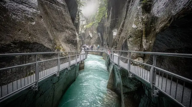
This is the one paid stop on the route and worth the detour even if you’ve budgeted the rest of the walk as free. The Trümmelbach is not a single waterfall but a series of ten glacier-fed cascades running inside a gorge cut into the mountain, carrying meltwater from the Eiger, Mönch and Jungfrau glaciers down to the valley floor. A funicular lift, included in the ticket, takes you partway up inside the rock to the main galleries, from where a system of tunnels and walkways lets you get close to several of the falls at different heights.
Entry costs around CHF 14 for adults and CHF 6 for children aged 6 to 16, paid at the door — it isn’t covered by the Swiss Travel Pass or the Berner Oberland Pass, since it’s a private attraction rather than a transport concession. It’s open seasonally, roughly April to November, and closed in winter when the falls partly freeze and access becomes unsafe. Bring a light waterproof if you have one; the spray inside the galleries is heavier than photos suggest, especially near the lower falls. Budget an hour if you want to see all the accessible levels rather than just the first gallery, which is where most rushed visitors turn back.
an e-bike tour that includes entry to the Trümmelbach falls is worth considering if you’d rather cover the valley faster and combine it with a wider loop than the plain walk described here.
Trümmelbach to Stechelberg
The final 1.2km narrows slightly as the valley approaches its head, with the cliffs on both sides closing in and the road losing its separated footpath in a couple of short stretches — walk facing traffic here and give way early, since visibility around the bends is limited. You’ll pass a scatter of further cascades feeding in from side valleys, none named on most maps but all worth a glance, particularly after rain when minor streams turn into respectable falls for a day or two.
Stechelberg itself is barely a hamlet: a cluster of houses, a couple of places to eat, and the valley station of the Schilthornbahn cable car, which runs up via Gimmelwald and Mürren to the Schilthorn summit at 2,970m. If your legs have more in them, riding up from here is the most direct way into the car-free villages above the valley floor without backtracking to Lauterbrunnen first. Stechelberg is also the trailhead for routes up toward the Sefinen valley and the via ferrata routes around Mürren and Gimmelwald, for anyone extending the day into something more strenuous.
Getting back
The PostBus stops right outside the Schilthornbahn station in Stechelberg and runs to Lauterbrunnen roughly every 20 to 30 minutes, with the journey taking about 15 minutes; most services continue on to Interlaken. It’s covered by the Swiss Travel Pass, the Berner Oberland Pass, the Jungfrau Travel Pass and Interlaken’s local hotel guest card, so check which of those you’re already holding before buying a separate ticket. Walking back the way you came is entirely possible — it adds no elevation, just another 45 to 60 minutes — but few people bother once they’ve seen the valley in one direction.
When to go and what to bring
The valley floor is walkable all year, since it follows a public road rather than a mountain trail that gets buried in snow. Summer brings the heaviest coach traffic and the busiest Trümmelbach queues, particularly late morning through early afternoon; an early start or a late-afternoon walk avoids most of it. Spring and early summer give the waterfalls their strongest flow, fed by snowmelt from the peaks above Wengen and the Jungfrau massif, while by September several of the smaller cascades have thinned noticeably.
Bring proper shoes rather than sandals — the surface is mostly good, but the Trümmelbach galleries are wet and can be slippery, and any rain turns the unpaved sections to mud quickly given how little sun the valley floor gets under the cliffs. Water and a hat matter more than the temperature suggests; despite the shade, the valley traps heat with almost no breeze on a still day. There is nowhere to buy food or drink between Lauterbrunnen and Stechelberg apart from a small kiosk at the Trümmelbach site, so carry what you need.
Who this walk suits, and who might skip it
The valley floor walk is a good first outing for anyone arriving in the region and wanting an easy introduction to the scenery before committing to a mountain railway. Families with young children, older walkers and anyone nervous about heights will find it comfortable, since nothing on the route involves exposure. It also works well as a gentle day after a demanding one, for instance following a long ridge hike from the best day hikes from Interlaken list.
It is less suited to travellers who want big views from above. The valley floor shows you the walls from underneath, which is impressive but different from the panoramas on offer from the heights. If views are the priority, compare the options in best mountain excursions from Interlaken and consider walking the valley as the quiet half of a day that also includes a summit. Travellers working to a tight budget will like that the walk itself costs nothing, and the Interlaken free things to do guide lists other ideas in the same spirit.
A few small habits make the walk better. Start with the Staubbachfall while the village is still quiet, take photographs on the way down the valley rather than saving them for the end, and keep the Trümmelbach visit for the middle of the walk, when you will welcome a break. Wear layers, since the shade and the spray can make it feel cooler than the forecast says, and keep your phone in a pocket you can reach easily, because the best views often appear suddenly at a bend in the road.
Walking versus cycling the valley
| On foot | E-bike | |
|---|---|---|
| Time, one way | 45–60 min | 15–20 min |
| Effort | Low, flat throughout | Very low, motor-assisted |
| Flexibility to stop | Highest — stop anywhere | Good, but momentum discourages short stops |
| Best for | First-time visitors, families, photographers | Combining with a longer loop or extra villages |
| Typical cost | Free (plus Trümmelbach entry) | Guided tour, priced per person |
If you’d rather not walk at all, or want to see more of the valley in the same morning, a guided e-bike tour through the valley’s waterfalls covers the same ground plus extra side roads in a fraction of the time, and a guided e-bike route through Lauterbrunnen with commentary along the way is aimed at visitors who want context on what they’re passing rather than a self-guided walk.
For those without their own transport into the valley at all, a waterfall tour with hotel pickup from Interlaken removes the need to manage trains and buses around the walk entirely.
Making it part of a longer day
The walk itself fills a morning at most, which leaves the rest of a day trip open. Combine it with the Trümmelbach falls as described above, then either ride the Schilthornbahn up toward Mürren if the weather is clear at altitude, or head back into Lauterbrunnen village for lunch and the train onward. Anyone planning a single day around Lauterbrunnen and its valley rather than the wider region should see the one-day Interlaken itinerary for how this slots in against the Jungfraujoch or Grindelwald First as alternatives on the same day.
For other flat, low-effort routes around the region on days when the mountain railways are closed for wind or the cloud base sits too low for a summit trip, see the roundup of easy flat walks around Interlaken, and for a broader view of hiking options by fitness level, the guide to the best day hikes from Interlaken puts this walk in context against steeper routes above the valley rim.
If poor weather rules out the cliffs and cable cars entirely, what to do in Interlaken when it rains covers indoor and low-lying alternatives, since the valley floor walk itself is one of the few routes in the region that stays reasonable in drizzle.
Anyone unfamiliar with how the region’s cable cars and rack railways connect villages that have no road access should read how the car-free villages work before combining this walk with a trip up to Mürren or Gimmelwald, and the Wengernalp railway guide is useful if you’re routing back via Wengen rather than the Stechelberg bus. For the practicalities of moving around the wider Bernese Oberland by public transport, including which passes cover which routes, see trains, buses and boats around Interlaken.
Hiking & nature tours on GetYourGuide
Verified deep-linked GetYourGuide tours. Book through these links and we earn a small commission at no cost to you.
GetYourGuide does not provide a product photo for this activity — the image shows the meeting point, photographed by us.