Niederhorn: funicular, cable car and the ridge to Gemmenalphorn
How do you get to the Niederhorn and is it worth it?
From Beatenberg, a funicular then a cable car take you to the 1,950 m summit in about 20 minutes combined. It is worth it for the close-up ibex herd and the near-vertical view down onto Lake Thun, which is more dramatic than most other Bernese Oberland viewpoints because the lake sits almost directly below the ridge.
The Niederhorn does not get the crowds or the marketing budget of the Jungfraujoch or the Schilthorn, and that is more or less the point of going. At 1,950 m it is the lowest of the Bernese Oberland’s named viewpoints, reached from the sun-terrace village of Beatenberg rather than from Interlaken directly, and the ride up is a funicular followed by a cable car rather than a single dramatic lift.
What you get for the trouble is a herd of ibex you can genuinely walk past on foot, a ridge path to a second summit with almost nobody on it, and a view down onto Lake Thun that is steeper and more vertiginous than the view from Harder Kulm or Schynige Platte, because the Niederhorn sits almost directly above the water rather than across the valley from it.
Getting up: funicular, then cable car
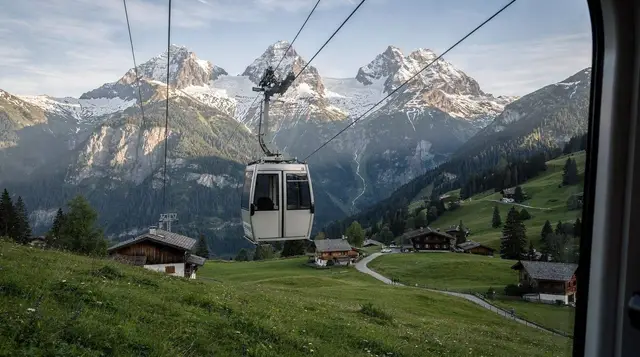
The Niederhorn is reached in two stages from Beatenberg, a long ridge-top village strung along a single road above Interlaken. The first stage is the Beatenberg–Niederhorn funicular, which climbs from the valley station to the mid-station at Waldegg. The second stage is a cable car (a Luftseilbahn, not a gondola with multiple cabins) from Waldegg to the summit station just below the actual top.
| Stage | Mode | Approx. time |
|---|---|---|
| Beatenberg valley station to Waldegg | Funicular | 8–9 minutes |
| Waldegg to Niederhorn summit | Cable car | 8 minutes |
| Combined, with a normal connection wait | Funicular + cable car | 20–25 minutes |
A return ticket for the full run is a reasonable outlay by Bernese Oberland standards, noticeably cheaper than a Jungfraujoch ticket, and covered at a discount by the Swiss Travel Pass and the regional Berner Oberland Pass. There is no direct connection from Interlaken; you have to get to Beatenberg first, by car, postbus, or the funicular that also starts near Interlaken Ost and climbs to Beatenberg itself before you change onto the Niederhorn line. Budget the whole door-to-door journey from central Interlaken at close to an hour each way once you count the approach to Beatenberg.
Getting there from Interlaken
Beatenberg sits on a shelf above the north shore of Lake Thun, reached either by postbus from Interlaken Ost or by the Beatenberg funicular, which starts near the lakeshore below the village and is a separate line from the Niederhorn funicular above the village. Drivers can take the road up from Interlaken via Sundlauenen, though parking in Beatenberg itself is limited and best done at the funicular’s valley station.
Some visitors combine the ascent with a stop at the Beatus Caves partway up the hillside, a genuinely impressive stalactite cave system with an underground waterfall, reachable on the same road out of Interlaken. It works well as a first stop before continuing up to Beatenberg and the Niederhorn lifts.
a combined Beatus Caves ticket with the small museum covers the underground walk and the exhibition on the caves’ history, and slots naturally into a half-day that continues up to Beatenberg afterwards.
If you would rather not manage the changes between postbus, funicular and cable car yourself, a private van route out of the area covers Beatus Caves and the Harder Kulm side of things in one booking: a private van tour taking in St Beatus Caves and Harder Kulm is aimed at travellers coming up from further afield, including Montreux, who want the sights strung together without working out the local transport themselves.
The ibex herd
The Niederhorn’s main claim to fame among locals, rather than tour operators, is its ibex (Steinbock) colony. Alpine ibex were hunted to extinction in Switzerland by the early nineteenth century and reintroduced from Italian stock through much of the twentieth; the Niederhorn population is one of the more accessible results of that programme, grazing the open slopes around and below the summit rather than retreating to inaccessible crags the way chamois tend to.
This is not a wildlife park and there is no fence. The animals are simply present on the hillside, most reliably in the early morning and again in the couple of hours before sunset, when they come out to feed on the open grass rather than sheltering from midday sun. Groups of females and young are the most commonly seen; the large males with the heavy curved horns tend to keep more to themselves and are more visible in autumn during the rut. Binoculars help but are not essential — sightings from thirty or forty metres on the marked path are routine in season, and a still, quiet approach does more than any piece of kit.
For a broader look at what else turns up on Bernese Oberland hillsides, from marmots to golden eagles, see the wildlife and marmots guide.
The ridge walk to Gemmenalphorn
From the Niederhorn summit station, a clear path runs west along the open ridge to the Gemmenalphorn, a second, slightly higher summit at 2,061 m. This is the single best short hike accessible from the top of the lift system: no technical ground, modest elevation change along the crest, and views that alternate between Lake Thun on one side and the peaks of the Jungfrau region on the other as the ridge turns.
Allow two to two and a half hours out and back at a comfortable walking pace, with sturdy shoes rather than trainers — the path is unpaved and can be muddy or icy at the margins of the season even when the lifts are running. There is no shade on the ridge, so sun protection matters on a clear day, and the exposure to wind that closes the cable car in bad weather applies just as much to walkers on foot. This is a fair-weather walk, not a challenge to attempt for the sake of it.
Fitter walkers looking for something longer in the same range should look at the Hardergrat ridge guide, a considerably more serious undertaking on the opposite side of the valley, or browse the best mountain excursions from Interlaken for how the Niederhorn stacks up against Harder Kulm, Schynige Platte and the higher glacier viewpoints.
The view over Lake Thun
What sets the Niederhorn apart from most of the region’s other belvederes is the angle. Harder Kulm, at 1,322 m, looks down the length of the valley and across at the Jungfrau peaks; Schynige Platte does something similar from a different shoulder of the same ridge system. The Niederhorn instead sits almost directly above the northern shore of Lake Thun, so the water appears nearly beneath your feet rather than laid out at a distance. On a clear day the villages of Sigriswil and Merligen and Oberhofen and Hilterfingen are visible strung along the far shore, with Thun and its castle at the lake’s northern end.
To the south, the view opens onto the higher Bernese peaks, though the angle is more oblique than from Harder Kulm; the Niederhorn is a lake-and-ridge viewpoint first, a glacier-panorama viewpoint second. For a comparison of the different summit views on offer around Interlaken, the viewpoints guide lays out which lift suits which priority.
Restaurant and practicalities
There is a restaurant at the summit station with a terrace facing the lake, serving the usual Bernese Oberland range of rösti, soup and cake at prices in line with other mountain restaurants in the area — reckon on paying noticeably more than valley prices for anything you order, which is standard for any restaurant reachable only by lift. It is a reasonable stop for coffee or lunch before or after the ridge walk, and it is the only food option at the top, so plan around its opening hours if you are timing a sunrise or sunset visit.
Toilets are available at both the mid-station and the summit. Mobile signal is generally reliable given how developed the Swiss network is, though it can drop briefly on the cable car section itself.
When it’s closed
Like most of the region’s smaller lift systems, the Niederhorn funicular and cable car close for scheduled maintenance in spring and again in autumn, typically for a few weeks each time, and the exact dates shift from year to year. Check the operator’s site before building a trip around the Niederhorn specifically, particularly if you are visiting in April, May, or November.
Separately from the seasonal closures, the cable car section between Waldegg and the summit is suspended in strong wind more readily than the funicular below it, since it is a single-cabin aerial line rather than a rail-bound funicular running in a cutting. A calm day in Beatenberg does not guarantee a calm day on the open summit ridge above, so if wind is forecast, check the live operating status rather than travelling up on the assumption that the lower stage running means the whole route is open. For a wider view of which lifts in the region are prone to this and when the whole network typically opens and closes for the season, see when mountain railways open and close.
Winter on the Niederhorn
The Niederhorn runs through winter as well as summer, serving a small ski and toboggan area rather than the large piste network of Grindelwald or the Jungfrau ski region. The best-known winter feature is the toboggan run down from the summit area towards Beatenberg, a long sledging track that draws families and groups looking for something less committing than the resort’s ski slopes; see the sledging and toboggan runs guide for how it compares to other runs in the area.
a guided day of sledging organised out of Interlaken is one way to do the toboggan run without sorting your own transport and sledge hire, and it typically bundles in a couple of runs rather than a single descent.
Snowshoeing on the gentler ground around the ridge is also popular once snow settles, away from the marked ski pistes; the ibex tend to move to lower, more sheltered ground in deep winter, so wildlife sightings are less reliable than in the warmer months. If you would rather have a guide pick the route and read the snow conditions, a guided snowshoe tour departing from Interlaken covers routes in this part of the Bernese Oberland and adjusts to conditions on the day. For the broader picture of what else opens up once snow arrives, see snowshoeing and winter hiking and Interlaken in winter.
Planning the visit
The Niederhorn works best as a half-day rather than a rushed add-on, because the approach through Beatenberg already takes time before the funicular and cable car themselves. A realistic plan is: travel to Beatenberg in the morning, ride up to the summit, walk the ridge to Gemmenalphorn and back, eat at the summit restaurant, and return down in the early or mid-afternoon while the ibex are still likely to be active. Trying to combine it with a second major excursion the same day, such as the Jungfraujoch or Schilthorn, is possible on paper but makes for a long day given the separate approach to Beatenberg.
For how the Niederhorn fits against the region’s other half-day and full-day options, the day trips from Interlaken guide sets it alongside Bern, Lucerne and the higher glacier excursions, and best time to visit Interlaken covers which months give the clearest odds of a wind-free, cloud-free summit.
Niederhorn: questions people ask
How do I get to the Niederhorn?
Travel first to Beatenberg by postbus, car, or the separate Beatenberg funicular from near Interlaken Ost, then take the Beatenberg–Niederhorn funicular to the mid-station at Waldegg and change onto the cable car for the final stage to the 1,950 m summit. There is no single direct lift from Interlaken itself.
Will I actually see ibex?
Sightings on or near the marked paths around the summit are common in the warmer months, especially early morning and early evening, though nothing in the wild is guaranteed. Winter sightings are less reliable as the herd moves to lower, more sheltered ground.
How long does the whole trip take from Interlaken?
Counting the journey out to Beatenberg, the two-stage ascent, some time at the summit or on the ridge walk, and the return, a realistic round trip runs to half a day, roughly four to five hours door to door depending on your connections and how long you linger.
Is the Niederhorn suitable for families?
Yes. The lifts do the height gain, the summit area is open and easy underfoot, and the ibex are a genuine draw for children in a way that a distant glacier view usually is not. The ridge walk to Gemmenalphorn is easy enough for older children but is a real walk, not a stroll, so pace it to the group.
Does the Swiss Travel Pass cover the Niederhorn lifts?
The pass gives a discount on the Beatenberg–Niederhorn funicular and cable car rather than free travel in most cases; check current terms before travelling, since discount levels on regional lifts change from season to season. Full details are in the Swiss Travel Pass guide.
What should I wear?
Sturdy, closed shoes for the ridge path, a windproof layer even in summer since the exposed ridge is noticeably colder and windier than Beatenberg below, and sun protection given the lack of shade above the treeline.
How does it compare to Harder Kulm for a quick trip from Interlaken?
Harder Kulm is faster and simpler: a single funicular starting near Interlaken Ost, an 8-minute ride, and you are at the viewpoint. The Niederhorn takes longer to reach because of the detour through Beatenberg, but rewards the extra effort with the ibex herd, the ridge walk, and a steeper, more direct view onto Lake Thun. See the Harder Kulm guide for the full comparison.
Mountain excursions on GetYourGuide
Verified deep-linked GetYourGuide tours. Book through these links and we earn a small commission at no cost to you.
GetYourGuide does not provide a product photo for this activity — the image shows the meeting point, photographed by us.